PT Luwes Inovasi Mandiri
When Rainfall Data Is Not Enough: Integrating Soil Moisture and Block-Based Fertilization Recommendations
Contributor: YP, LS
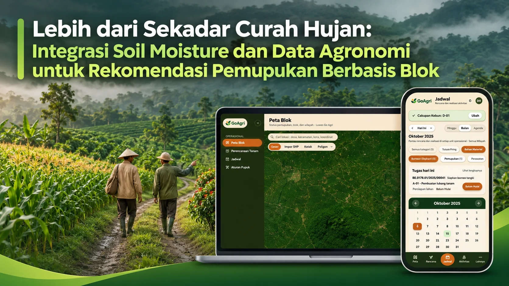
By integrating rainfall data, soil moisture, and agronomic conditions, GoAgri supports more timely, efficient, and site-specific fertilization decisions tailored to the needs of each agricultural block.
Depok, Indonesia – Rainfall is often one of the first pieces of information agricultural and plantation management teams consider when planning field operations. However, rainfall measurements alone cannot fully answer one important question: how much water is actually available in the soil, particularly within the plant root zone?
Two plantation blocks receiving similar amounts of rainfall may not necessarily have the same soil moisture conditions. Differences in soil texture, topography, drainage, vegetation cover, and root depth can produce different soil water responses.
This demonstrates that agricultural decision-making cannot rely on a single environmental variable. Rainfall information must be evaluated alongside soil moisture conditions and crop management requirements.
This integration forms the foundation of precision agriculture: connecting environmental data with more location-specific operational decisions.
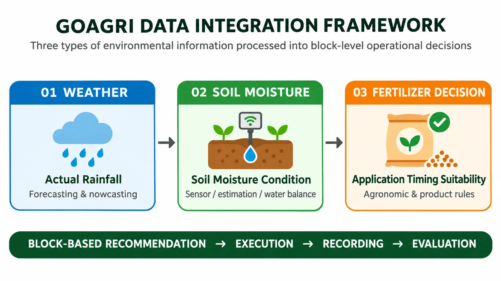
Figure 1. Conceptual framework for integrating weather data, soil moisture, and block-based fertilization decisions. This diagram illustrates the technological concept and does not imply that all integrations are currently available in the existing product version.
Rainfall Is a Water Input, Not a Complete Picture of Soil Conditions
Rainfall represents the amount of water falling from the atmosphere onto the land surface during a specific period. This information is essential for understanding water inputs, seasonal patterns, and opportunities for conducting field operations.
However, not all rainfall is stored within the plant root zone. Some water may be intercepted by vegetation canopies, flow away as surface runoff, evaporate, or move deeper into the soil through percolation.
Therefore, the relationship between rainfall and soil moisture is influenced by land characteristics.
For example, sandy soils generally exhibit different infiltration and water retention behavior compared with clay soils. Land slopes can increase surface runoff, while drainage conditions and root depth influence how long water remains available to plants.
The same amount of rainfall does not automatically result in the same soil moisture content.
In practice, rainfall data also has temporal and spatial dimensions.
Daily rainfall totals do not always explain rainfall intensity or its distribution throughout the day. Meanwhile, a single rain gauge represents conditions at a specific observation point and may not capture rainfall variations across an extensive plantation area.
For this reason, rainfall observations, weather forecasts, and plantation block mapping should be interpreted together according to the spatial and temporal scale of the decisions being made.
Soil Moisture: Understanding Water Stored in the Soil
Soil moisture refers to the water content within soil pores at a particular location, depth, and measurement time.
This variable is important because it is closely related to water availability for plant roots, hydrological processes, and plant responses to environmental conditions.
Babaeian et al. (2019) explain that soil moisture can be monitored through direct field measurements, proximal sensors, and satellite-based remote sensing.
Each method has different spatial coverage, sensing depths, observation frequencies, and sources of uncertainty.
Measurements using sensors installed in the soil can provide information at specific locations and depths.
Remote sensing can help identify spatial variations across larger areas. However, satellite-derived soil moisture products should not automatically be considered representative of the entire root zone.
Measurement depth, vegetation cover, soil properties, spatial resolution, and estimation methods must be evaluated before such data is used to support agronomic decisions (Babaeian et al., 2019; Zhang et al., 2024).
This distinction is essential.
Surface soil moisture, near-surface soil moisture, and root-zone soil moisture are not identical variables.
Plants absorb water through root systems whose depth varies depending on crop type, plant age, soil conditions, and growth stage.
Therefore, soil moisture data should be interpreted alongside soil characteristics and crop information rather than treated as a single uniform value applicable to every plantation block.
Soil Water Balance Connects Rainfall, Soil Conditions, and Crop Water Requirements
One framework for describing changes in water storage within the root zone is the soil water balance.
The FAO-56 approach uses reference evapotranspiration (ETo), crop coefficients (Kc), and crop evapotranspiration (ETc) to estimate crop water requirements.
A soil water balance model then considers water inputs and losses to describe changes in water storage within the root zone (Allen et al., 1998; Pereira et al., 2020).
Simplified Root-Zone Water Balance Equation
ΔS = P + I − ETc − R − D
In this simplified equation:
ΔS: Change in soil water storage
P: Precipitation
I: Irrigation
ETc: Crop evapotranspiration
R: Surface runoff
D: Drainage or deep percolation below the root zone
All components must be expressed using consistent water-depth units and time periods.
This equation serves as a conceptual illustration. Operational implementation requires a defined root-zone boundary, effective rainfall estimates, soil characteristics, crop parameters, and calibration based on actual field conditions.
The soil water balance helps transform weather observations into meaningful information about water availability.
For example, heavy rainfall does not necessarily increase root-zone water storage proportionally if a substantial portion becomes surface runoff or moves beyond the root zone.
Conversely, a period without rainfall does not automatically indicate that crops are experiencing water deficits if sufficient moisture remains stored in the soil.
Therefore, the model must consider initial soil water conditions and changes in water storage over time (Pereira et al., 2020).
Why Are Soil Water Conditions and Weather Important for Fertilization Timing?
Fertilization is an agronomic activity influenced by fertilizer type, soil properties, crop conditions, application methods, and weather.
After fertilizers are applied, nutrients may undergo various transformations and movements within the soil–plant system.
For nitrogen, relevant processes include ammonia volatilization, nitrification, nitrate leaching, and denitrification.
These processes can influence nitrogen use efficiency and potential nutrient losses (Cameron et al., 2013; Motasim et al., 2024).
Rainfall following fertilizer application is not always harmful.
Under certain conditions and with specific fertilizer formulations, water can help dissolve nutrients and transport them into areas accessible to plant roots.
However, excessive rainfall, surface runoff, or deep percolation may increase the risk of nutrients being transported beyond the root zone.
The magnitude of this risk depends on fertilizer type, application rate, soil properties, topography, application timing and methods, as well as rainfall intensity and distribution.
Therefore, there is no single universal rainfall threshold suitable for every fertilizer type and agricultural field.
Evidence from oil palm plantations in Sumatra highlights the importance of location-specific conditions.
Prabowo, Lim, and Nelson (2026) compared two sites with average annual rainfall of 1,668 mm and 4,094 mm.
At the wetter site, potassium (K) and magnesium (Mg) losses through runoff and deep drainage were equivalent to approximately 33% and 30% of fertilizer inputs, respectively.
At the other site, the corresponding losses were approximately 4% and 6%.
These figures were obtained from specific research sites and experimental conditions and should not be treated as universal benchmarks for all oil palm plantations.
Instead, the findings demonstrate that nutrient-loss risks must be understood according to local environmental conditions.
Research by Rahutomo and Ginting (2018), conducted on Inceptisol soils from oil palm plantations in North Sumatra, also demonstrated that the quantities of nitrogen (N), phosphorus (P), and potassium (K) lost through leaching varied depending on the type and characteristics of fertilizers tested.
These findings reinforce the importance of considering fertilizer-specific application requirements rather than relying solely on rainfall information when determining application timing.
From Environmental Data to Block-Based Recommendations
Integrating rainfall, soil moisture, and agronomic information becomes more valuable when the results are connected to specific management locations.
Across large plantations and agricultural operations, conditions may differ between blocks due to variations in soil properties, topography, drainage, crop age, and historical field activities.
A block-based approach allows environmental data, operational recommendations, and field activities to be recorded and managed within the same spatial unit.
Conceptually, an agricultural decision-support workflow may include several stages:
Collecting weather data and land characteristics.
Estimating or observing soil moisture conditions.
Applying soil water balance models and agronomic rules.
Assessing the suitability of field activities for each block.
Recording implementation and evaluating operational results.
Agricultural decision-support systems are designed to connect data, models, and user requirements so that information can support practical decision-making rather than simply adding more data to a dashboard (Zhai et al., 2020).
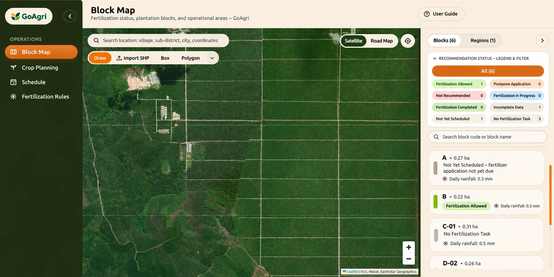
Figure 2. GoAgri Block Map dashboard displaying plantation block polygons, recommendation status indicators, block search functionality, and daily rainfall information. Source: GoAgri product documentation provided for article preparation.
How Is This Approach Being Implemented in GoAgri?
GoAgri is being developed as a block-based agricultural decision-support system.
Within its product roadmap, the fertilization module is designed to help users plan activities, assess suitable application timing, carry out field operations, record implementation, and evaluate results.
Initial recommendations focus on application timing and environmental suitability. The minimum viable product (MVP) is not intended to automatically determine fertilizer application rates.
Through the Block Map interface, users can view plantation block boundaries, select or search for specific blocks, and monitor fertilization recommendation statuses.
The sample dashboard includes several operational status categories:
Fertilization Allowed
Postpone Application
Fertilization Not Recommended
Fertilization in Progress
Fertilization Completed
Incomplete Data
Not Yet Scheduled
No Fertilization Task
Daily rainfall information is also displayed to provide environmental context.
With this block-based structure, operational conditions can be assessed at a more specific land-management level rather than relying on a single summary for the entire plantation.
GoAgri's development roadmap also includes six-day weather forecasts and daily fertilization recommendations that consider weather conditions, the FAO-56 soil water balance, land characteristics, and fertilizer-specific application rules.
Additional planned developments include integrating SPIRE soil moisture predictions, incorporating soil pH as one indicator of soil health and fertilizer suitability, and utilizing historical fertilization records.
Therefore, the integration of these three major components represents a phased development direction rather than a claim that all features are already operational within the current dashboard.
The value of this approach lies in decision traceability.
Ideally, each recommendation should explain the reasoning behind it, the sources and completeness of the supporting data, relevant limitations, and the associated level of confidence.
Once field activities are completed, records containing block identification, application dates, fertilizer products, responsible personnel, and implementation status can support further evaluation.
This feedback data is essential for assessing whether recommendations match actual field conditions and for improving decision rules and models in subsequent development stages.
Data Limitations and the Importance of Field Validation
Integrating multiple datasets does not automatically guarantee accurate recommendations.
Soil moisture sensors must be installed and calibrated according to soil characteristics and measurement depths.
Satellite-derived information has specific spatial resolutions and sensing-depth limitations, while root-zone estimates depend on the models and assumptions used.
Weather forecasts also contain uncertainties that vary according to location and forecast lead time.
Incomplete, unrepresentative, or outdated data must therefore be identifiable by both the system and its users.
Digital recommendations should consequently be treated as decision-support tools rather than absolute instructions.
Operational thresholds must be validated by agronomists and adjusted according to crop type, growth stage, soil properties, fertilizer products, application methods, and local environmental conditions.
In high-risk situations or when available data is insufficient, field verification remains necessary.
A phased approach that connects recommendations, implementation, and evaluation can help establish a more transparent, explainable, and trustworthy agricultural decision-support system.
Toward More Context-Aware Agricultural Management
Rainfall provides information about water entering the land surface from the atmosphere.
Soil moisture helps describe the amount of water stored within the soil.
Meanwhile, agronomic information and fertilization rules connect environmental conditions with appropriate agricultural management actions.
These three components serve different purposes, but their value increases when they are interpreted together and linked to specific plantation or agricultural blocks.
For plantation managers and agricultural operators, this integrated approach creates opportunities for more context-aware planning.
The key question is no longer simply how much rainfall has occurred, but also how much water is available in the soil, what the conditions mean for crop requirements, and whether a particular field activity is appropriate for a specific block.
Through the development of its block-based decision-support system, GoAgri aims to connect environmental intelligence with agricultural planning, field execution, operational recording, and performance evaluation.
Interested in Smarter Agricultural Decision-Making?
Would you like to explore how weather intelligence and block-based recommendations can support your agricultural operations?
Contact the PT Luwes Inovasi Mandiri team to discuss environmental monitoring requirements and data-driven decision-making solutions tailored to your agricultural or plantation management area.
Keywords: Soil Moisture, Rainfall, Fertilization Recommendations
PT Luwes Inovasi Mandiri
Industrial IoT & Monitoring Solutions
Website: www.luwesinovasimandiri.com
Instagram: @luwesinovasimandiri
LinkedIn: Luwes Inovasi Mandiri
Facebook: LuwesSolutions
WhatsApp: +62 811-8185-5558
Office: Depok, West Java, Indonesia
References
Allen, R. G., Pereira, L. S., Raes, D., & Smith, M. (1998). Crop evapotranspiration: Guidelines for computing crop water requirements. FAO Irrigation and Drainage Paper 56. Rome: Food and Agriculture Organization of the United Nations. https://www.fao.org/4/X0490E/X0490E00.htm
Babaeian, E., Sadeghi, M., Jones, S. B., Montzka, C., Vereecken, H., & Tuller, M. (2019). Ground, proximal, and satellite remote sensing of soil moisture. Reviews of Geophysics, 57(2), 530–616. https://doi.org/10.1029/2018RG000618
Cameron, K. C., Di, H. J., & Moir, J. L. (2013). Nitrogen losses from the soil/plant system: A review. Annals of Applied Biology, 162(2), 145–173. https://doi.org/10.1111/aab.12014
Motasim, A. M., Samsuri, A. W., Nabayi, A., Akter, A., Haque, M. A., Abdul Sukor, A. S., et al. (2024). Urea application in soil: Processes, losses, and alternatives—a review. Discover Agriculture, 2, Article 42. https://doi.org/10.1007/s44279-024-00060-z
Pereira, L. S., Paredes, P., & Jovanovic, N. (2020). Soil water balance models for determining crop water and irrigation requirements and irrigation scheduling focusing on the FAO56 method and the dual Kc approach. Agricultural Water Management, 241, 106357. https://doi.org/10.1016/j.agwat.2020.106357
Prabowo, N. E., Lim, H. S., & Nelson, P. N. (2026). Potassium and magnesium losses via runoff and leaching under oil palm at contrasting sites. Nutrient Cycling in Agroecosystems, 133, Article 31. https://doi.org/10.1007/s10705-026-10533-w
Rahutomo, S., & Ginting, E. N. (2018). Leaching level of N, P, K, and several types of fertilizer. Jurnal Penelitian Kelapa Sawit, 26(1), 37–47. https://doi.org/10.22302/iopri.jur.jpks.v26i1.35
Zhai, Z., Martínez, J. F., Beltran, V., & Martínez, N. L. (2020). Decision support systems for agriculture 4.0: Survey and challenges. Computers and Electronics in Agriculture, 170, 105256. https://doi.org/10.1016/j.compag.2020.105256
Zhang, X., Feng, G., & Sun, X. (2024). Advanced technologies of soil moisture monitoring in precision agriculture: A review. Journal of Agriculture and Food Research, 18, 101473. https://doi.org/10.1016/j.jafr.2024.101473
Explore equipment and discuss your requirements
Start with the technology guide if you are still comparing options. The team can help review what your site needs.