Shallow Water Mapper: Satellite Technology for Mapping Shallow-Water Depths
Published
PT Luwes Inovasi Mandiri
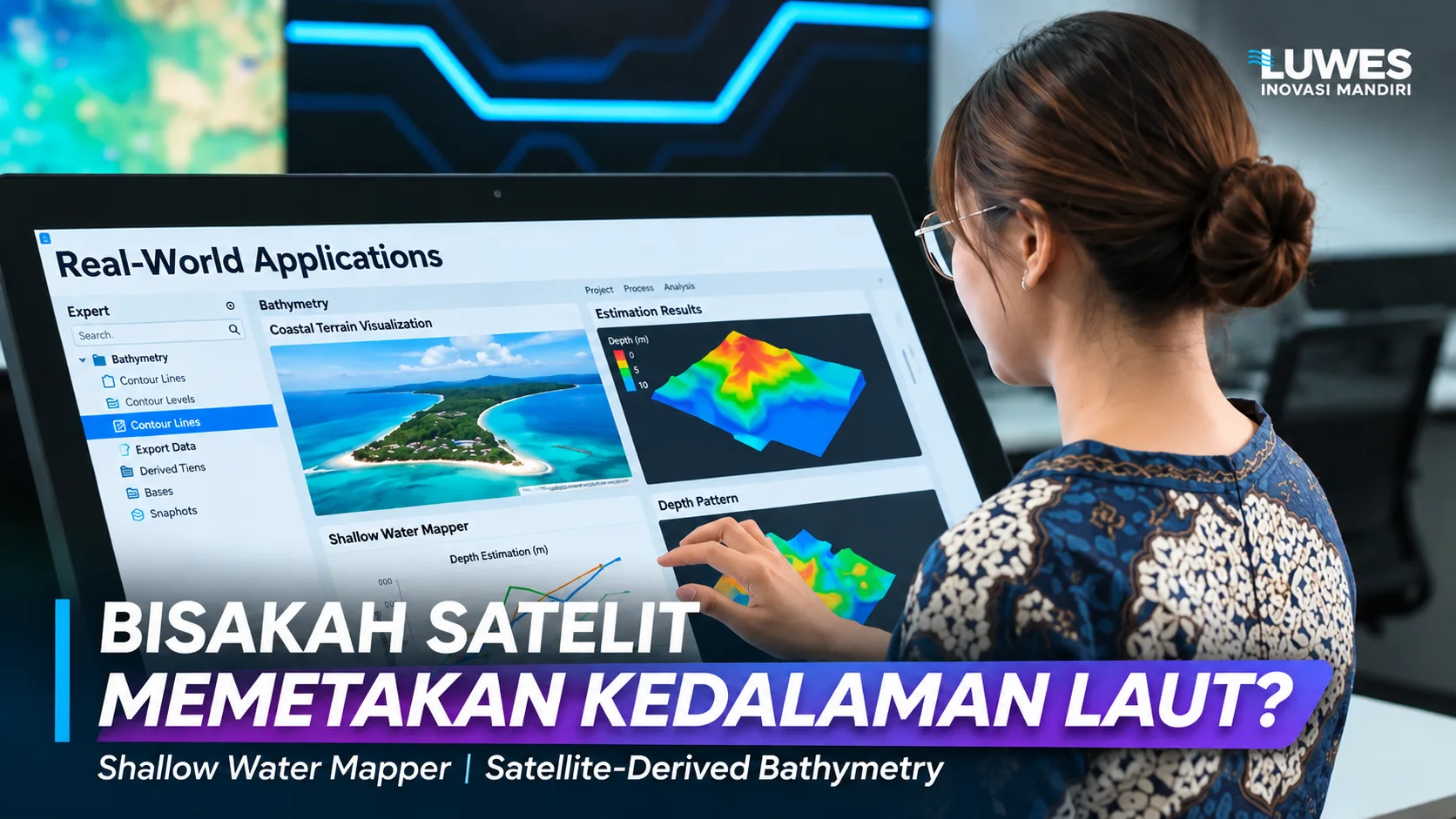
The use of satellite imagery offers a new approach to mapping shallow-water depths. Through Satellite-Derived Bathymetry (SDB), information about the water surface and seabed can be processed into estimated depth maps to support hydrographic surveys, coastal management, and marine spatial planning.
Depok - Shallow-water environments play an important role in various human activities, ranging from coastal management and marine environmental research to the development of maritime infrastructure. However, understanding the characteristics of the seabed is not a simple task.
Water depths can vary significantly from one location to another. Differences in seabed topography, sediment distribution, and coastal environmental dynamics are among the factors that must be considered when developing bathymetric information.
Traditionally, water depths have been measured through field surveys using instruments such as echo sounders, which utilize sound waves to determine the distance between a sensor and the seabed.
Although these methods provide direct depth measurements, their implementation requires specialized equipment, survey personnel, and operational planning suited to the characteristics of the surveyed area.
Advancements in remote sensing technology have introduced a complementary approach through the use of satellite imagery.
One such technology is Satellite-Derived Bathymetry (SDB), a method that estimates water depth using spectral information captured by satellite sensors.
In Indonesia, PT Luwes Inovasi Mandiri has developed this approach through Shallow Water Mapper, a satellite imagery processing solution designed to identify shallow-water depth patterns and support the planning of subsequent survey activities.
Understanding Satellite-Derived Bathymetry Technology
Satellite-Derived Bathymetry is a method of estimating water depth by analyzing the interaction between light, the water column, and the seabed as recorded by optical satellite imagery.
When sunlight reaches the water surface, some of its energy is reflected, while the remaining portion penetrates the water column. As light travels through water, its intensity decreases due to absorption and scattering.
Under relatively clear and shallow-water conditions, some optical information reflected from the seabed can reach satellite sensors.
Differences in these spectral responses can then be analyzed to estimate variations in water depth.
However, satellite imagery does not measure depth directly in the same way as sonar equipment. Instead, depth information is derived through modeling processes involving image processing and, depending on the method applied, reference depth measurements.
Therefore, interpreting bathymetric results requires careful consideration of water characteristics, image quality, and model uncertainty.
In practice, Shallow Water Mapper combines satellite imagery selection, spectral information processing, depth estimation, and comparison with field measurements.
The resulting output provides a preliminary representation of depth distribution that can help identify areas requiring further investigation.
How Does Shallow Water Mapper Work?
Satellite-based depth mapping involves more than simply acquiring an image and converting its colors into a bathymetric map.
Several processing stages are required to ensure that the selected imagery is appropriate for the environmental conditions and intended analytical objectives.
The Shallow Water Mapper workflow consists of three main stages.
1. Defining the Study Area and Selecting Satellite Imagery
The first stage involves defining the boundaries of the water area to be analyzed.
Establishing these boundaries provides the foundation for determining mapping coverage, spatial resolution requirements, and the availability of supporting data.
Satellite imagery may be obtained from programs such as Landsat and Sentinel, with data selection adjusted according to project requirements and water conditions.
Not all satellite images are immediately suitable for bathymetric analysis.
Cloud coverage, acquisition dates, sunlight reflection from the water surface, and water clarity must be carefully evaluated.
Images affected by atmospheric disturbances or unfavorable surface conditions may reduce the quality of the information obtained.
Consequently, satellite imagery selection is a critical step in determining whether an area is suitable for satellite-based bathymetric mapping.
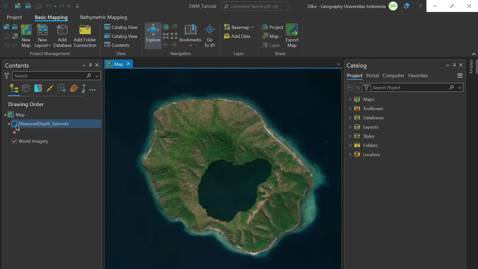
Figure 1: Initial view showing the land, coastline, and surrounding waters.
2. Image Processing and Depth Estimation
Once suitable imagery has been selected, the next stage involves processing the data to extract information related to water characteristics.
This process may include image correction and spectral analysis, particularly using visible-light and near-infrared bands.
These spectral characteristics support image interpretation, including identifying water areas suitable for further processing.
A depth estimation model is then applied to generate an initial representation of underwater depth distribution.
Within a digital mapping environment, the results can be presented as raster layers illustrating variations in estimated water depth across the study area.
These outputs allow users to examine spatial depth patterns and generate depth contour lines.
Contour lines help visualize changes in water depth, making it easier to identify areas with different underwater characteristics.
Nevertheless, the colors displayed on a map or the contour lines generated by a model do not automatically confirm that all estimated depths accurately represent actual seabed conditions.
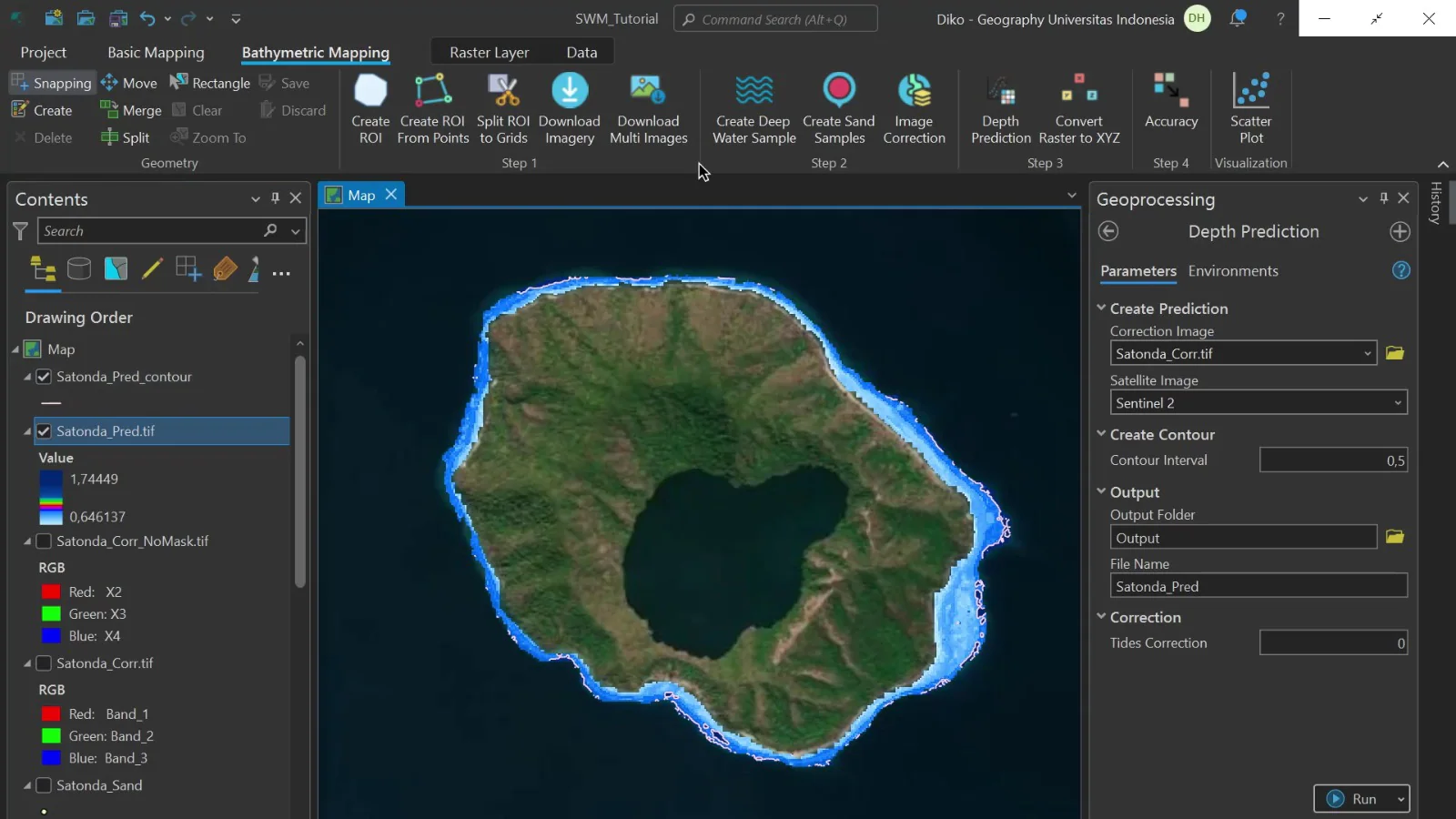
Figure 2: Review the legend and processing settings. Map colors alone do not verify actual measured water depths.
3. Comparing Results with Field Measurements
The next stage involves comparing satellite-derived depth estimates with measurements obtained through direct field surveys.
These measurements serve as reference information to support model development and result verification.
Such comparisons are necessary because the relationship between spectral information and water depth may vary considerably between locations.
Seabed composition, water turbidity, and other environmental characteristics can influence depth estimation results.
Additionally, the consistency of measurement locations, acquisition dates, and vertical water-level references must be considered.
When available, validation data that are independent of the data used to develop the model should be used to provide a more objective assessment of estimation performance.
This approach ensures that mapping results are evaluated not only by their visual appearance but also by their consistency with actual field conditions.
Expanding Opportunities for Preliminary Coastal Mapping
Satellite-derived bathymetry has important applications in coastal planning and management.
Information about underwater depth patterns can provide an initial understanding of marine environments before more detailed field surveys are conducted.
In regional planning, preliminary bathymetric maps can support area assessments, help identify locations requiring further investigation, and guide subsequent data collection activities.
One of their primary benefits is supporting survey planning.
Through satellite image analysis, technical teams can identify areas that may require additional depth measurements, allowing field operations to be planned using available preliminary information.
This approach can also support aquatic environmental research, particularly studies requiring spatial representations of coastal characteristics.
In coastal resource assessments, preliminary bathymetric information can serve as supporting data for understanding the physical conditions of the study area.
However, its application must always be aligned with the level of accuracy required.
Maps developed for preliminary assessments have different requirements from depth datasets intended for navigation safety or engineering applications.
These differences are important considerations when selecting the most appropriate mapping method.
Water Clarity as a Critical Factor
Although Satellite-Derived Bathymetry provides an approach to mapping underwater environments without direct measurements across every part of the study area, the technology has several limitations.
One of the most important factors is water clarity.
In relatively clear waters, optical information reflected from the seabed is more likely to be captured by satellite sensors.
Conversely, in highly turbid waters, light may experience greater absorption and scattering before reaching or returning from the seabed.
These conditions can make depth estimation significantly more difficult.
Suspended materials, variations in seabed composition, and disturbances at the water surface may also influence the quality of spectral information.
Furthermore, cloud cover and sunlight reflections from the water surface can interfere with satellite image interpretation.
Deep-water environments present another challenge because optical information from the seabed becomes increasingly difficult to detect as water depth increases.
As a result, not all marine areas can be mapped with the same level of reliability.
In locations where optical observation requirements cannot be met, alternative survey methods may still be necessary.
Therefore, an assessment of satellite image suitability should be conducted before concluding that an entire area can be mapped using satellite-based technology.
The Importance of Validation and Data Uncertainty
In bathymetric mapping, the primary challenge is not simply producing a map but determining the reliability of the information it presents.
Depth maps contain processed information that may influence technical decisions. Incorrect interpretation can produce a misleading representation of actual underwater conditions.
For this reason, comprehensive documentation of the mapping process is essential.
Information such as satellite acquisition dates, study area boundaries, coordinate reference systems, processing configurations, and reference depth measurements should be stored alongside the mapping outputs.
Such documentation enables users to trace how a map was produced and understand the limitations of its application.
Changes in water level caused by tidal fluctuations must also be considered when relevant to the study area and mapping objectives.
Without a consistent vertical reference, comparisons between satellite-derived estimates and field measurements may become unreliable.
In technical evaluations, bathymetric mapping results should ideally present not only estimated depth distributions but also identify areas suitable for analysis, locations where methodological requirements are not met, and known levels of uncertainty.
This principle is important to prevent users from assuming that every part of a bathymetric map has the same level of reliability.
Can Satellite-Derived Bathymetric Maps Be Used for Navigation?
One frequently raised question regarding satellite-based bathymetry is whether the resulting depth maps can be used directly for maritime navigation.
The answer is not automatically.
Depth information used for navigational safety must comply with applicable survey requirements, accuracy standards, and other relevant regulations.
Satellite-derived depth estimates cannot automatically be considered equivalent to hydrographic survey results that meet these requirements.
The same considerations apply to dredging operations, marine infrastructure construction, and other engineering activities that require specific levels of accuracy and quality assurance.
For such applications, the selection of survey methods must consider the risks associated with data use and the technical requirements of the project.
Therefore, Shallow Water Mapper is more appropriately understood as a tool for preliminary mapping and assessment that can complement professional survey activities.
Satellite technology and field surveys should not necessarily be regarded as competing approaches. Instead, they can complement one another depending on project objectives and requirements.
Integration with Geographic Information Systems
Satellite-derived bathymetric outputs can also be incorporated into geographic information management systems.
Through a Geographic Information System (GIS), depth information can be displayed alongside other spatial datasets relevant to the study area.
In project planning, this integration enables users to examine estimated depth distributions while considering administrative boundaries, coastal characteristics, and other survey information.
However, integrating bathymetric outputs into GIS applications requires compatible data formats, coordinate reference systems, and spatial layers.
Therefore, output requirements should be established during the initial planning stage.
Users should also ensure that mapping documentation, supporting datasets, and explanations of methodological limitations are available so the information can be interpreted and applied appropriately.
The Role of Satellite Technology in the Future of Marine Mapping
Advancements in remote sensing technology continue to expand the range of methods available for understanding aquatic environments.
Satellite-Derived Bathymetry is one relevant approach because it enables preliminary analysis of underwater depth patterns using information collected without directly surveying every location.
Through Shallow Water Mapper, PT Luwes Inovasi Mandiri provides a system that combines satellite imagery, spatial data processing, and field reference measurements to support shallow-water bathymetric mapping.
This approach can help users develop an initial understanding of coastal and marine environments while identifying requirements for further surveys.
However, its effectiveness remains dependent on environmental conditions, the availability of suitable satellite imagery, and the quality of reference measurements.
As coastal management increasingly relies on spatial information, technologies such as Satellite-Derived Bathymetry have the potential to become valuable components of data-driven planning processes.
Ultimately, successful bathymetric mapping is not determined solely by sophisticated software or visually appealing maps.
Data reliability, methodological accuracy, and a clear understanding of technical limitations remain the fundamental requirements for producing trustworthy and defensible bathymetric information.
Primary Source: Shallow Water Mapper – Satellite-Based Bathymetry, PT Luwes Inovasi Mandiri.
Product Information: https://luwesinovasimandiri.com/produk/shallow-water-mapper/
PT Luwes Inovasi Mandiri
Industrial IoT & Monitoring Solutions
🌐 Website: www.luwesinovasimandiri.com
📷 Instagram: @luwesinovasimandiri
💼 LinkedIn: Luwes Inovasi Mandiri
📘 Facebook: LuwesSolutions
📲 WhatsApp: +62 811-8185-5558
📍 Luwes Office: Depok, West Java, Indonesia