From Tides to Data: Real-Time Monitoring for Coastal Infrastructure
An AWLR and telemetry-based coastal monitoring system continuously records water level changes and integrates the data into a monitoring dashboard to support coastal and marine infrastructure monitoring.
Coastal areas are continuously affected by tides, waves, weather, human activity, and other marine dynamics. These conditions make environmental monitoring increasingly important, particularly around ports, estuaries, aquaculture areas, reclamation zones, and coastal protection structures.
One of the key parameters that can be monitored continuously is water level.
For this purpose, a telemetry-enabled Automatic Water Level Recorder (AWLR) is increasingly used as part of modern coastal monitoring systems.
Why Continuous Water Level Monitoring Matters
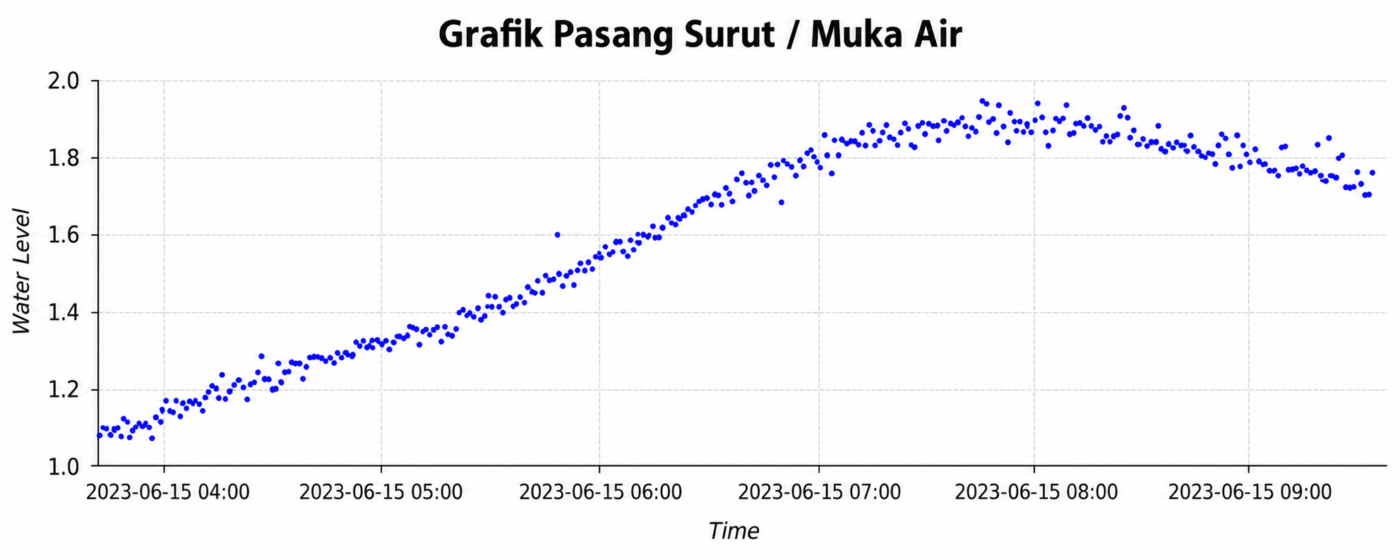
Figure 1. The water level chart shows changes in water elevation over time, including rising and falling trends
Manual water level observations still have an important role in certain activities. However, they have limitations when users require continuous data over long periods.
An AWLR can automatically record changes in water level at configurable intervals.
The collected data forms a time series, allowing operators to observe rising and falling water levels, compare conditions across different periods, and maintain historical records for technical documentation.
In coastal environments, this data can also serve as one of several supporting sources for evaluating changes in water conditions over time.
The Role of Telemetry in Coastal Areas
One of the main challenges in coastal monitoring is site accessibility.
Some monitoring points are located far from operational centers, while weather, tides, and wave conditions can restrict field access.
With telemetry, data from an AWLR can be transmitted automatically to a central server using the available communication network.
Operators can then monitor conditions through an integrated dashboard without having to visit the site continuously.
The dashboard can display information such as:
current water level;
water level trends and historical records;
device and communication status; and
geospatial locations of monitoring stations.
This approach allows field data to be monitored more consistently and documented over time.
Selecting the Right Sensor for Coastal Environments
Coastal environments present challenges that differ from inland monitoring sites.
Saltwater exposure, corrosion, high humidity, tides, waves, and mounting structure conditions all need to be considered during system planning.
Sensor selection should therefore match the characteristics of the monitoring location.
Non-Contact Radar Sensor
Radar sensors can be suitable for certain sites because measurements are performed without direct contact with the water.
This configuration can help reduce direct exposure to saltwater and may simplify maintenance under specific conditions.
Submersible Pressure Sensor
Pressure sensors can be used in installations where the site configuration allows a submerged sensor to be positioned safely and securely.
Sensor selection should consider not only measurement accuracy, but also installation requirements, environmental protection, maintainability, and long-term operation.
Why Water Level Data Alone Is Not Always Enough
Water level is an important coastal monitoring parameter, but coastal conditions are influenced by many other factors.
For more comprehensive analysis, AWLR data can be considered together with information such as wave conditions, wind, rainfall, current data, CCTV, and field inspection results.
Combining multiple sources of information helps operators better understand coastal conditions without relying on a single parameter as the sole basis for evaluation.
The Role of AWLR in Coastal Protection Infrastructure
Coastal protection structures such as seawalls, breakwaters, revetments, and groins are designed to perform specific functions according to local conditions.
An AWLR does not directly measure the structural strength of these assets.
However, water level data can provide additional environmental context around the structure.
When combined with visual inspections, wave data, current information, and other relevant parameters, the data can support engineers in evaluating environmental conditions surrounding coastal protection infrastructure.
Integrated Coastal Monitoring Solutions
Every coastal area has different characteristics.
Estuaries, ports, reclamation areas, aquaculture zones, and coastal protection structures may each require a different monitoring configuration.
For this reason, site surveys and monitoring objectives should be defined before selecting equipment.
PT Luwes Inovasi Mandiri provides coastal water level monitoring systems that can be tailored to project requirements, including sensors, dataloggers, telemetry systems, power supply, and monitoring dashboards.
The system can also be integrated with CCTV, weather sensors, and other data sources where required.
If your institution or company is planning a coastal water level monitoring system, consult your AWLR, telemetry, and dashboard requirements with PT Luwes Inovasi Mandiri.
PT Luwes Inovasi Mandiri
Industrial IoT & Monitoring Solutions
🌐 www.luwesinovasimandiri.com
📷 Instagram: @luwesinovasimandiri
💼 LinkedIn: Luwes Inovasi Mandiri
📘 Facebook: LuwesSolutions
📲 whatsapp : +62 811-8185-5558
📍 Kantor Luwes : Depok, West Java, Indonesia