Automatic Water Level Recorder (AWLR)
Track changing water levels.
Water can rise between field visits. AWLR records water levels at your site, helping your team follow changes and decide when a closer check is needed.
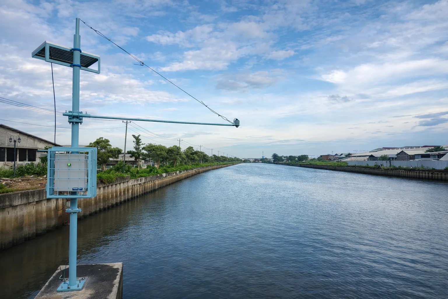
A clearer picture between visits.
Measure above the water
A radar sensor reads the water surface without touching it. Its position and reference height are set for each site.
Keep a record of changes
Measurements form a water-level history for your team to review alongside field observations.
Choose how data reaches you
Data transmission, power and reading intervals are planned around network coverage and the team's needs.
AWLR / Inside the design
One station. Each part has a purpose.
Explore the components, then rotate the assembled station in 3D.
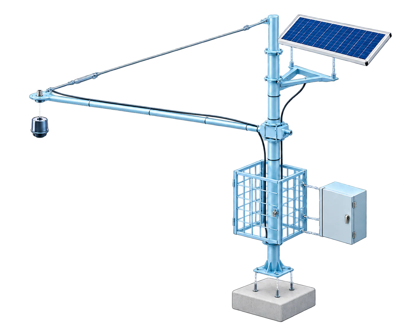
Drag to rotate · + / − to zoom
Surface transparency shows the model geometry, not the electronics inside.
From measurement to record
Designed to work together.
- 01
Water-level measurement
The radar sits above the water and measures without contact.
- 02
Solar power
The panel supplies power for field operation.
- 03
Protected control unit
The cabinet houses the equipment that records and manages measurements.
Illustration and reference model. The final equipment follows your site configuration.
From the water surface to your team's review.
Measurements support observation. Warning thresholds and response procedures must be agreed for the site.
- 01
Set the reference
Survey the mounting point and height reference before installing the sensor.
- 02
Read the surface
The radar measures the distance to the water surface at the chosen interval.
- 03
Record and transmit
The recorder saves readings. Remote delivery depends on the installed connection.
- 04
Review the change
Read trends and agreed thresholds to decide what needs checking.
Where water levels shape the work.
Rivers and drainage
Follow rising and falling water levels as part of local observation and warning procedures.
Reservoirs and dams
Review level records alongside operating schedules and field inspections.
Irrigation canals
Understand changes in canal levels to support water-distribution planning.
Plan the configuration for your site.
Measurement setup
- Method
- Non-contact radar
- Height reference
- Established at the installation site
- Range and accuracy
- Specified for the selected sensor model
Installation and data
- Power
- Solar panel and battery configuration
- Remote connection
- Selected after checking site coverage
- Reading interval
- Set to suit the monitoring task
Make an informed choice
Is AWLR right for your water-monitoring site?
Start with the decision your team needs to make: check a river, follow reservoir levels or watch an irrigation canal. AWLR, an automatic water-level recorder, helps build that record without relying only on occasional visits.
Choose level monitoring, not a different measurement
AWLR reads water level at a selected point. It does not directly measure water quality or river discharge, meaning the amount of water flowing each second. If discharge is required, discuss additional measurements and a site-specific relationship between level and flow. If rain is the main question, compare ARR instead.
The mounting point matters
The radar measures from above the water. A site review checks a stable support, expected low and high water levels, obstacles below the sensor and a height reference that the team can find again. Power, access during floods and permission to work on a bridge or riverbank also belong in the plan.
Ask for a complete station scope
Ask the quotation to identify the sensor model, recorder, mounting structure, power equipment, transmission method and data access. Include installation, testing, operator training and any ongoing connection or platform charges. Range and accuracy must match the offered model; a photo or 3D illustration does not define the delivered package.
Plan for missed connections and regular checks
Separate the measurement interval from the time data reaches the screen. Ask how the selected recorder stores readings during a connection failure and whether it sends them afterwards. Agree checks for reference height, sensor alignment, power and unusual readings. Alerts require agreed limits and someone responsible for reviewing and acting on them.
Questions before you buy
Can it measure river flow?
Not from the level reading alone. A flow assessment needs additional site data and a suitable method.
Does the sensor touch the water?
The radar configuration shown measures above the surface. Mounting height and sensor choice are reviewed for your site.
Will readings arrive during a network outage?
Remote delivery needs a working connection. Confirm local storage, recovery and notification behaviour for the proposed unit.
Can I use the data in my existing dashboard?
Share the receiving system and required data format. Compatibility, access and integration work must be checked first.
Does AWLR replace a flood-warning procedure?
It supplies observations. Thresholds, communication routes and field responses still need a local operating procedure.
What determines the price?
The sensor, site works, power, connection, software and service scope. Request an itemised quote, including recurring costs.
Examples and further reading
References for the explanation
These explain measurement or system principles. The equipment and service offered are confirmed in your quotation.
Where do you need to follow the water?
Tell us about the water body, mounting point, network coverage and how your team will use the readings.