GNSS CORS · Mobile CORS + D303-RTK
Positioning for fieldwork.
Bring a common reference to your survey points. The Mobile CORS station supplies correction data, while the D303-RTK receiver helps collect positions for mapping, asset records and field measurements.
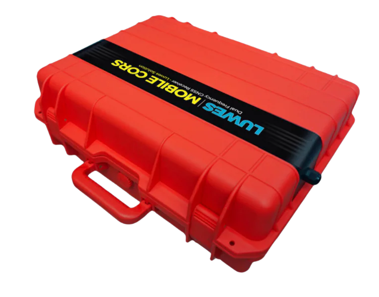
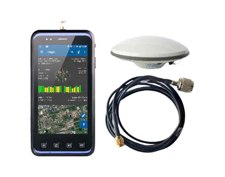
- 01Reference station
- 02Correction data
- 03Field position
How it works
A shared reference, from base to field.
Both the reference station and the field receiver observe satellite signals. Correction data connects their roles.
Follow the measurement
The base observes satellite signals at a reference position and supplies correction data.
A compatible connection delivers corrections to the receiver. The chosen method and availability are checked before surveying.
The receiver combines its observations with corrections to record survey points. Sky visibility, connection and receiver status affect the result.
Concept illustration. Configuration follows the site design.
Two roles. One field workflow.
A reference station supplies correction data. The field receiver uses it while recording your survey points.
The reference point
GNSS Mobile CORS
The reference station receives and records satellite signals. Its correction data gives compatible field receivers a common positional reference.
- Receives GNSS signals at a reference location
- Supplies correction data in RTCM format
- Supports real-time correction and later data processing
- Records GNSS data for review and archival
The receiver you take to the field
D303-RTK
The Android-based receiver combines GNSS signals with correction data. An external antenna and field software support point collection for surveying and mapping.
- Receives signals from multiple satellite systems
- Android-based field settings and point collection
- Wi-Fi and 4G LTE for correction-data access
- Position data for compatible mapping software
From satellite signals to recorded points.
- 01
Receive the signals
The reference station receives satellite signals at its known location.
- 02
Prepare corrections
The system processes observations into correction data for compatible receivers.
- 03
Connect the receiver
The field receiver obtains correction data through the configured connection.
- 04
Check and record
Check the receiver's solution status before saving survey points.
Where the positions become useful.
Survey points
Collect positions for topographic mapping and survey records using the method and control points your project requires.
Asset locations
Record utility and asset positions for a shared map that field teams can revisit.
Construction reference
Use a consistent positional reference when collecting site measurements and checking mapped points.
Repeat observations
Plan repeat measurements with suitable control, equipment and expert review when studying position changes.
Match the setup to your survey.
Check sky visibility, the correction-data connection, distance to the reference station and the required survey method. Actual accuracy depends on these conditions and the receiver status.
D303-RTK configuration reference
These values describe the D303-RTK configuration in the product information. Confirm the current model, antenna and supplied configuration before purchase. They are not guaranteed results at every site.
GNSS System
- Channels
- 250
- Constellations
- GPS, GLONASS, Galileo, BDS, QZSS
- Frequencies
- L1/L2, G1/G2, E1/E5b, B1/B2/B3
RTK Accuracy
- Horizontal
- 0.02 m + 1 ppm CEP
- Vertical
- 0.04 m + 1 ppm CEP
- Initialisation time
- 30 seconds
Communication
- WiFi
- 2.4/5GHz
- Cellular
- 4G LTE
- Bluetooth
- 4.0LE
Hardware
- Operating System
- Android 5.1 OS
- Display
- 5" Display 720p
- Protection
- IP65 Rated
Platform & Storage
- Operating System
- Android 5.1
- CPU
- Quad-core 64 bits 1.3GHz
- RAM / Storage
- 2GB / 16GB (extendable)
Positioning Performance
- GNSS Mode
- GPS + GLONASS + Galileo • GPS + BDS + Galileo
- Time to First Fix
- Cold Start < 30s • Hot Start: 1s • Re-acq < 1s
- Output rate
- 1Hz
Field Hardware
- Display / Touch
- 5" 1280×720 sunlight readable / Capacitive Multi-Touch
- Camera
- 13MP, autofocus, LED flash
- Battery
- 3.7V 3200mAh
Connectivity & Protection
- Cellular Network
- GSM: B2, B3, B8 • WCDMA: B1, B8 • TDD-LTE: B38, B39, B40 • FDD-LTE: B1, B3
- Interface
- 1× MicroUSB • 1× MicroSD (32GB) • 1× SMA (GNSS antenna)
- Protection Rating
- IP65, 1.2m drop resistant
Make an informed choice
Plan the positioning workflow before choosing a receiver
GNSS uses satellite signals to determine position. A CORS reference station supplies correction data; an RTK field receiver uses corrections during surveying. The right combination depends on the survey, available correction service and the quality of the working environment.
A reference station and a field receiver have different jobs
First decide whether you need to collect points, establish a local reference or monitor position over time. An existing compatible correction service may change which equipment you need. Ask how the selected receiver receives corrections and what must be provided at the reference location. Buying one component does not automatically provide the full workflow.
Check the sky view and the correction connection
Buildings, trees and reflected signals can affect positioning. The reference point must be stable and known, and the correction link needs to suit the working area. Do not assume a stated centimetre-level capability applies everywhere. Ask for a site demonstration, quality indicators and a procedure for rechecking measurements against known points.
Agree the coordinate system and survey outputs
Position data must use the correct coordinate and height reference for the project. Confirm software compatibility, file formats, correction-service access and subscriptions. The quotation should list receivers, antennas, mounting equipment, power, software, training and any connection work. Review model-specific specifications and required calibration or checks separately.
Keep the quality record with the point
A coordinate without its measurement conditions can be misleading. Agree records of time, correction status and relevant quality information. Ask what the receiver can record when corrections are unavailable and whether later processing is supported. Battery, antenna position and changes around the reference station need routine checks before repeated surveys are compared.
Questions before you buy
Do I need both devices?
Not always. Existing correction services and your survey task determine whether a new reference station is needed.
Is centimetre accuracy guaranteed anywhere?
No universal figure applies to every site. Signal conditions, corrections, setup and the selected receiver affect the result.
Can it work near tall buildings?
Obstruction and reflected signals need assessment. Demonstrate the workflow in conditions similar to your actual survey.
Does RTK need an internet connection?
It needs correction data through the selected delivery method. Confirm the connection and alternatives for your package.
Can files enter our mapping software?
Check formats, coordinate systems and the receiving software version before ordering.
Can the same equipment monitor structural movement?
That requires a dedicated measurement design, stable references and a suitable analysis process; it is not just a survey mode switch.
Compare and explore
Examples and further reading
References for the explanation
These explain measurement or system principles. The equipment and service offered are confirmed in your quotation.
Where will your team collect points?
Share the location, area, existing equipment and required output. We can review the reference station, receiver and correction connection together.