Automatic Groundwater Level Monitoring with AWLR for Wells and Raw Water Sources
AWLR helps monitor groundwater levels and raw water sources automatically and in real time. The system integrates sensors, data loggers, telemetry, data storage, and dashboards to support monitoring and decision-making. Luwes Inovasi Mandiri provides an integrated AWLR solution that has been deployed in Indonesia and several other countries.
Automatic Water Level Recorder (AWLR) is a solution for automatically monitoring groundwater levels and raw water sources. The system helps operators obtain water-level data periodically without relying on continuous manual measurements.
Water-level monitoring is important because water conditions can change due to seasonal variations, rainfall, groundwater extraction, and environmental changes. With continuously recorded data, changes in water availability can be monitored more effectively.
The Geological Agency of Indonesia’s Ministry of Energy and Mineral Resources uses AWLR systems in monitoring wells to measure and record groundwater-level changes in real time.
Why Is Groundwater Level Monitoring Important?
Groundwater levels can rise or fall due to groundwater recharge, dry seasons, rainfall, and pumping activities.
Historical monitoring data helps operators identify groundwater-level trends over time. This information can support the evaluation and management of water resources.
The USGS explains that long-term groundwater-level data is important for understanding changes in groundwater systems and the effects of water use on aquifers.
How Does an AWLR System Work?
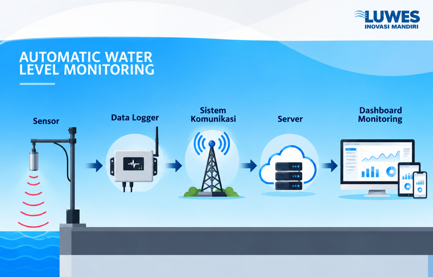
Gambar 1 : AWLR system architecture
In simple terms, the AWLR system architecture can be described as:
Sensor → Data Logger → Communication System → Server → Monitoring Dashboard
The sensor measures the water level. The data is then recorded by the data logger and transmitted through a communication network to a server. The information can then be displayed on a dashboard in the form of numerical values, graphs, and device-status information.
This system enables real-time or near-real-time water-level monitoring without requiring operators to remain at the monitoring site.
AWLR for Wells and Raw Water Sources
AWLR can be used for groundwater monitoring wells as well as various raw water sources. For surface water applications, monitoring can be implemented in rivers, reservoirs, retention ponds, and water storage basins.
The collected data helps operators identify water-level changes, seasonal patterns, and long-term rising or declining trends.
Reference: Directorate General of Water Resources, Ministry of Public Works, 2026.
AWLR Solutions from Luwes Inovasi Mandiri
PT Luwes Inovasi Mandiri provides integrated AWLR solutions for automatic, accurate, and remote water-level monitoring.
The system integrates non-contact radar sensors, data loggers, telemetry, data storage, solar power, and monitoring dashboards within a single ecosystem. Luwes has deployed more than 1,500 monitoring points across Indonesia, with projects and users extending to Timor-Leste, the United States, and Brunei.
From field sensors to monitoring dashboards, Luwes delivers more measurable, connected, and accessible water monitoring to support better decision-making.